Adam Savage’s Awesome Man Cave Hits Google Street View

If you have ever watched an episode of Mythbusters, you know who Adam Savage is. He is the ginger that builds so many of the contraptions that smash myths – or prove them correct – on the show. He also has an awesome man cave, as you might guess.

adam savage street view 620x542magnify

If you ever wondered what his personal workshop looks like, thanks to Google Maps Street View, you can now check it out. It’s a very cool place complete with full-size C-3PO and Chewbacca statues, an Atari Millipede arcade game, and thousands of awesome and creepy props and masks from movies, TV shows and commercials.Heck, he’s even got Hellboy in his bathroom.

adam savage street view 2 620x542magnify

Savage also has a YouTube video up where he goes over exactly what is hidden away in his space. Check out the video below and see all of what this sweet place of things manly and geeky has to offer – then head to Google Street View and start exploring for yourself.

[via The Mary Sue]

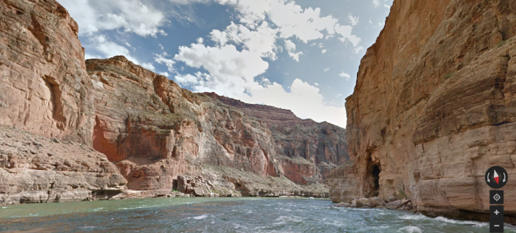
You Can Explore The Colorado River In Google Street View

colorado-river-street-view

Some lucky Google employees (in partnership with American Rivers) have spent some time going down the Colorado river with their imaging equipment, this much is clear. Because it seems that you can now explore the famous waterway in all its glory from the comfort of your home. No need to spend on pricey helicopter tours, or even getting a single drop of water on your nature-averse body. Click, point, and pan all you want folks, the river that carved the Grand Canyon awaits your 21st century explorer spirit.

[ Colorado River Street View ] AND [ Google Blog Post ] VIA [ Gizmodo ]

The post You Can Explore The Colorado River In Google Street View appeared first on OhGizmo!.

Street View update maps North America’s biggest parks and monuments

Google's Street View may have already taken us on a virtual tour of some US national parks, but its total number of natural sites now sits at an impressive 44 US and Canadian locations. With permission from the US National Park Service and Parks Canada, the search giant's cars, trikes and backpack-worn Trekker units have mapped some of most picturesque and historical sites in North America, providing us with new 360-degree views of Mount Rushmore, the Alamo Mission in Texas and the crystal-clear lakes of Banff National Park, to name but a few. All of these different locations -- with multiple trails -- are online now and you can check them out by hitting the source below.

Filed under: ,

Comments

Source: Google Maps, Google Lat Long Blog

Google Street View Explores Venice Italy

I’ve always found it curious that the entire city of Venice, Italy is built on the water. The way to get around much of the city is by boat, and the main thoroughfares are canals between different buildings and walkways. As close as I’ve ever gotten to exploring Venice, Italy is watching James Bond chase bad guys around the city.

google venice 620x487magnify

If you want to explore Venice, but can’t afford the airfare, Google has announced that its Street View imagery is now available for all of the canals and walkways of Venice. To grab the Street View imagery, Google workers used their Trekker Backpack and covered 265 miles on foot and 114 miles by boat.

Google says that it covered all the major attractions in Venice and also covered some of the lesser-known features including the synagogue of the first Jewish Ghetto and the Devil’s Bridge on Torcello Island. Google has even offered up a behind-the-scenes video showing how it captured some of its Street New footage in Venice. This is way cooler than those Street View images of CERN and the Large Hadron Collider.

[via Laughing Squid]

British canal boaters, welcome to Google Street View

In the same way that you can't really call The Hitchhikers Guide to the Galaxy a trilogy any more, Google's once again stretching the definition of a street. The company has loaned out one of its backpack-worn trekker units to the UK's Canal and River trust, which will document 100 miles of the country's waterways for Street View. Users will be able to tour London's Regent's Canal, the Bingley Five Rise and the Stoke Brueme blacksmiths on the Grand Union Canal. Just remember folks, even if you're touring from the comfort of your laptop, it's not a proper rambling holiday unless you bring a packed lunch and a flask of weak lemon drink.

Filed under: ,

Comments

Via: Pocket-lint, TechRadar

Source: UK Canal & River Trust

Google Earth update brings Street View and streamlined interface to iOS

Google Earth update for Android and iOS brings Street View and streamlined interface

Google's taking the iOS version of its Earth mapping app up to 7.1. The update brings a few new features, including, most notably, the addition of its Street View imagery -- following a similar update to the Android version. Also on the docket are improved transit, walking and biking directions, which can be viewed in 3D. The interface has been streamlined too, with a number of informational layers like Wikipedia located under a handy Earth logo in the top left off the app. The release of 7.1 also marks the app's availability in more than 100 countries. More info on the update can be had in the source link below.

Filed under: , ,

Comments

Source: Google Lat Long Blog

Watch how Google brought Street View to the Burj Khalifa (video)

Google Street View comes to the Burj Khalifa video

Street View's fine for navigation, but we're sure plenty more people use it just for their armchair tourism. Google has now turned its attention to giving thrill-seekers a chance to gaze out from the top of Dubai's Burj Khalifa, the world's tallest building. Using Trekker backpacks and trolleys, it took the Googlers three days to capture the images from both the viewing gallery on the 124th floor and the window cleaning gantry on the 80th. Curious to experience some of that vertigo for yourself? Video's after the break.

Filed under: , ,

Comments

Via: Official Google Blog

Source: Google Street View

Google Maps brings you to Everest, Kilimanjaro with all your toes intact

Google Maps brings you to Everest, Kilimanjaro with all your toes intact

Living vicariously just got a bit more exciting. Google Maps had added some of the most famous (and highest) mountains in the world to Street View. The list includes Aconcagua, Kilimanjaro, Mount Elbrus and Everest Base Camp -- four members of the Seven Summits, letting you explore some of the of the highest points on Earth without the aide of a breathing apparatus. According to Google, the shots were captured with the help of a tripod and a fish-eye-sporting digital camera. All of the aforementioned mountains can be reached in the source link below -- or with the assistance of a good support team.

Filed under: ,

Comments

Source: Google

Google Maps with Street View arrives on Nintendo Wii U in Japan, free for a limited time

Google Maps with Street View arrives on Nintendo Wii U in Japan, free for a limited time

True to Iwata-san's word, Google Maps with Street View is indeed making its way to the Nintendo Wii U this month. Word of the mapping service's impending arrival first came this past December, but at the time, no mention was made of availability outside of a vague January 2013 launch. As we learned later however, it was pushed back another month but Wii Street U Powered by Google is live in Japan, and will be free through the end of May. After that, there will be a fee for access to the service's Panorama View-like feature, which leverages the GamePad for 360-degree perspectives.

Of course, you can also peruse both plain and Street View maps from the TV, but that kind of diminishes the gimmicky point of the second screen controller. (Also, you could just use a laptop, tablet or phone for Google Maps -- just sayin'.) There's no word on US release plans or potential pricing, but it's worth noting the TVii app that's free here carries a nominal 100 yen charge in Japan. Hit the source link for an interview with the team behind bringing the app to the console.

Filed under: , , , ,

Comments

Source: Nintendo Japan (Twitter), Nintendo Wii Street U interview

Google Says It Didn’t Kill a Donkey with a Street View Car in Botswana

Sometimes truth really is stranger than fiction. We’ve seen some odd photos turn up on Google Street view over the years. My personal favorite was the little girl who played dead on the side of the road as the Street View car rolled by. A donkey has now played a very similar game with a Street View car in Botswana.

street view donkey

To make this an even stranger story, it started to go viral after a tweet from the account of fictional character Dr. Sheldon Cooper saying that “I think Google Street view ran over a donkey in Botswana.” The story gained enough traction the Google has had to come out and offer up an official explanation of the circumstances surrounding the downed donkey.

Google says that because of the way its 360-degree imagery is put together it appeared as though it’s Street View car cruising down a dirt road in Botswana had run over the poor creature. Google says that in fact the donkey was laying down and taking a dirt bath as the car approached, and then stood up and moved to the side of the road as the vehicle drove by.

donkey 1

Having known someone who rear-ended a cow, and assuming running over a donkey would work basically the same way as running over a cow, I can say without a doubt that there would have been donkey poo all over the front of the Street View car had an impact actually taken place. If you’re curious, the rear-ended cow survived with nothing more than an significantly cleaner colon after the impact. Sadly, the same can’t be said for the vehicle.

[via TheNextWeb]