Google Maps Android API 2.0 lets developers tune apps for tablets, head indoors (video)

Google Maps Android API 20 lets developers tune apps for tablets, offer indoor maps video

As aggressive as Google has been about pushing updates to Google Maps for Android, large swaths of those additions have been unavailable to third-party app developers. They're now on a more level playing field now that a version 2.0 Maps API is rolling out the door. The revamp is more accommodating of tablets and other big-screen gear through support for Android Fragments; many of Maps' more advanced information layers, such as indoor maps, are likewise exposed to those who don't work at a Google campus. The additions are already finding their way into apps from Trulia and a handful of others, but every other mobile developer with a cartographic bent can hit the source to upgrade their handiwork.

Continue reading Google Maps Android API 2.0 lets developers tune apps for tablets, head indoors (video)

Filed under: , , ,

Comments

Via: Lat-Long Blog

Source: Google Developers

Google brings indoor maps to desktop web browsers

Google brings indoor maps to desktop web browsers

It may not be quite as practical as the mobile version if you find yourself lost in the mall this holiday season, but those looking to plan their shopping route ahead of time can now finally take advantage of Google's indoor maps in their desktop web browser. That new addition, just rolled out today, does come with a bit of a catch, though: the desktop version of indoor maps is only offering the main floor of buildings for the time being, with no word yet on when the ability to view additional levels will be added (something that can currently be done in the Android app). Of course, the availability of indoor maps is still quite a bit more limited than some of Google's other map offerings, but it does now include over 10,000 floor plans in a number of different countries.

Filed under: ,

Comments

Via: @GoogleMaps (Twitter)

Source: Google

New Kinda Spy Cam

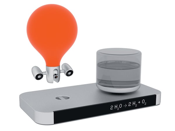
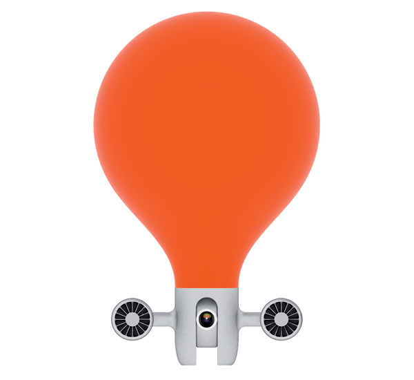
The Zipper is a flying indoor camera and recording device that can be used in a number of scenarios. The device uses the principle of gas balloons and combines it with the wit of propellers driven by a precision electric motor. Basically the hovering camera moves around a room very fast and silently and doesn’t consume much energy.

Application fields:

  • Film productions: unrestricted camera work
  • Surveillance: flexible monitoring of public locations like department stores, train stations, etc.
  • Security: video inspection in hard to access places like cable chutes and sewers
  • Private: webcam, babysitting, etc. or as a toy
  • Further recording options (sound, heat and radio activity) are possible with the matching sensors

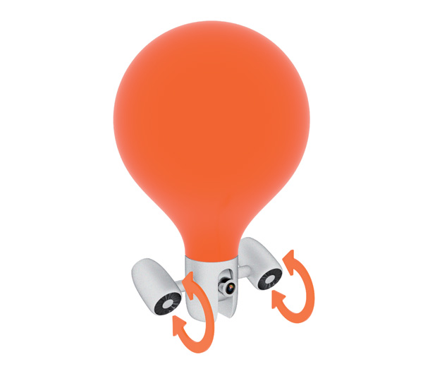
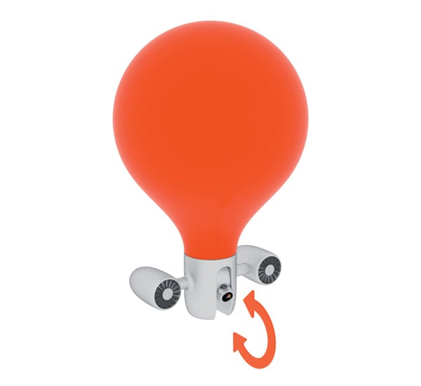
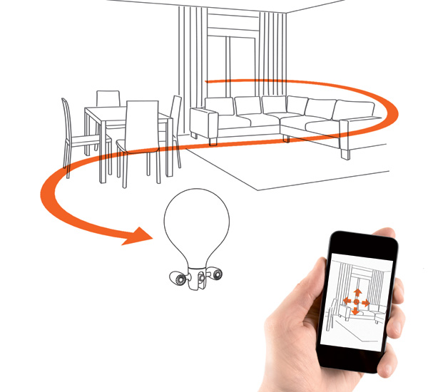
Two precision electric motors with propellers that are controlled via a processor allow horizontal movements. The alignment angle of the electric motors can also be controlled magnetically via the processor so that the Zipper is able to change its height flexibly and fast with these motors. The camera can be panned by 270 degrees, which allows different perspective also in standstill. Zipper can design recordings through different camera perspectives very dynamically and flexibly, which results in completely new possibilities in camera work. This means that the director can determine the motion path and speed of the camera beforehand three-dimensionally without having to deal with any restrictions or obstacles in the room. This allows novel and free design when changing scenes and perspectives. The motion path and speed can be set either beforehand in a 3D program or in realtime and interactively via joystick or remote control. The recorded images and further information are transmitted parallel, directly and wireless to other devices like computers or smartphones.

Function mode:

Zipper uses hydrogen as gas in order to float in the air like a balloon. The required gas quantity is controlled exactly via a processor using measurement and control technology so that the Zipper is always located at the desired height.

Water Electrolysis:

A charging station supplies the Zipper with energy and hydrogen. In doing so, water molecules are split into oxygen and hydrogen by means of electrolysis. The additionally generated oxygen is released into the air and ensures a good room climate. The charging station is supplied via low-voltage direct current and must only be refilled with water occasionally.

Zipper is a 2012 red dot award: design concept winner.

Designer: Emami Design

-
Yanko Design
Timeless Designs - Explore wonderful concepts from around the world!
Yanko Design Store - We are about more than just concepts. See what's hot at the YD Store!
(New Kinda Spy Cam was originally posted on Yanko Design)

Related posts:

  1. Kinda Like Hypercolor For Babies
  2. It’s a PC, No It’s a Lamp. Wait, It’s Kinda Both
  3. New Kinda Treasure Hunt


Google Maps for Android takes navigation indoors for France, helps find your way through Carrefour

Google Maps for Android takes navigation indoors for France, helps find your way through Carrefour

Interior navigation with Google Maps for Android has usually been the province of only a handful of regions at best. But what about Provence? While the deal isn't all-encompassing, Google is now serving indoor maps for popular locations throughout France. Coverage starts with the major airports in Paris and Lyon, extending to include major nationwide stores like Carrefour and FNAC, shopping centers like the Carrousel du Louvre and museums like La Géode. All told, over 50 venues have signed onboard and should be enough for those moments when you're rushing to catch a connecting flight at Orly... or just want to find the salad dressings in aisle three.

Filed under: , ,

Google Maps for Android takes navigation indoors for France, helps find your way through Carrefour originally appeared on Engadget on Tue, 25 Sep 2012 15:55:00 EDT. Please see our terms for use of feeds.

Permalink Google Lat-Long Blog  |  sourceGoogle  | Email this | Comments

Canopy Lets You Gaze at the Bright, Morning Sky – While You’re on the Subway

Whenever I want to spend some time alone to mull things over, I trek off to this park I like, find a bench, and literally just stare off into space. There’s just something relaxing and comforting about an overlooking mountain view that puts my mind (and heart) at ease.

Unfortunately, not all of us have the time to take regular trips out of the city (or even to a city park) just to calm our minds. But thanks to design students Matt Batchelor, Amitra Kulkami, and Emma Laurin, your commutes are about to become more relaxing.

Canopy Concept

They came up with the Canopy concept, which uses a curved display to show an animation of the sky or surface landmarks as the train or subway you’re riding in passes them. Think of it like a sun roof of sorts, only the digital kind. Though the prototype appears to use some sort of projection system, the concept calls for large, flexible electrophoretic e-paper displays.

Canopy Concept1

Mass transit operators can also choose to monetize on the added comfort by adding unobtrusive digital ads that interested commuters can check out by scanning the ad’s QR code.

It’s definitely a bright idea that will give people more things to look forward to for their long, dark underground commutes.

[via PSFK via Dvice]


Nokia grows Destination Maps coverage to 4,605 venues in 38 countries, coming to Nokia Maps soon

Nokia grows Destination Maps coverage to 4,605 venues in 38 countries, coming to Nokia Maps soon

After covering more than 23 million miles of the world's roadways, Nokia has focused on expanding its interior mapping footprint. Since its launch during CTIA 2011, the company's Destination Maps service has grown to cover a total of 4,605 different venues in 38 countries, including airports, department stores, shopping malls and transit hubs. As you can see in the infographic above, the majority of those locations are in North America, with a total of 2,595 mapped on the continent, followed by 1,778 in EMEA, 225 in the Asia Pacific region and just seven in Latin America -- that's 235 million square feet in all. Nokia also promises much more to come in the future, with hints identifying amusement parks and stadiums as possible beneficiaries. The company also reiterated its recent partnership with Bing, adding that Nokia Maps will have access to Destination Maps in the not-so-distant future as well. You'll find a few more details at the source link below, and while we don't have precise predictions to share, you can rest easy knowing that Nokia's indoor effort is far from complete.

Filed under: ,

Nokia grows Destination Maps coverage to 4,605 venues in 38 countries, coming to Nokia Maps soon originally appeared on Engadget on Mon, 16 Jul 2012 22:23:00 EDT. Please see our terms for use of feeds.

Permalink WMPoweruser  |  sourceNokia  | Email this | Comments

Google Maps adds floor plans and walking directions for 20 US museums

Google Maps adds floor plans and walking directions for 20 US museums

Getting lost can be half the fun of any leisurely museum excursion, but if you'd prefer to navigate your indoor outing with a level of precision typically reserved for trips across town, you'll want to bring Google Maps along on your next journey to the Smithsonian. Mountain View just added 20 US museums to its battery of 10,000 indoor schematics, including the de Young Museum in San Francisco, the Philadelphia Museum of Art, Cincinnati Museum Center, the Indianapolis Museum of Art, the American Museum of Natural History, 17 Smithsonian museums and the National Zoo in DC. You can find the plans for any venue by searching or hitting the current location button once you're on site, and Google plans to continue growing its collection, with SFMOMA, The Phillips Collection, the Nelson-Atkins Museum of Art and the National WWII Museum in New Orleans set to join soon. Meanwhile, institutions interested in joining forces with Google can use the company's Floor Plans tool to get the process started. Full details are at the source link below.

Filed under: ,

Google Maps adds floor plans and walking directions for 20 US museums originally appeared on Engadget on Tue, 10 Jul 2012 16:21:00 EDT. Please see our terms for use of feeds.

Permalink   |  sourceGoogle Lat Long Blog  | Email this | Comments

IndoorAtlas uses disturbances in the (geomagnetic) force to map interiors, plot a path to aisle 3 (video)

IndoorAtlas uses disturbances in the geomagnetic force to map interiors, keep us on track in aisle 3 video

Interior navigation is only just coming into its own, but IndoorAtlas has developed a technology that could make it just as natural as breathing -- or at least, firing up a smartphone's mapping software. Developed by a team at Finland's University of Oulu, the method relies on identifying the unique geomagnetic field of every location on Earth to get positioning through a mobile device. It's not just accurate, to less than 6.6 feet, but can work without help from wireless signals and at depths that would scare off mere mortal technologies: IndoorAtlas has already conducted tests in a mine 4,593 feet deep. Geomagnetic location-finding is already available through an Android API, with hints of more platforms in the future. It will still need some tender loving care from app developers before we're using our smartphones to navigate through the grocery store as well as IndoorAtlas does in a video after the break.

Continue reading IndoorAtlas uses disturbances in the (geomagnetic) force to map interiors, plot a path to aisle 3 (video)

Filed under: ,

IndoorAtlas uses disturbances in the (geomagnetic) force to map interiors, plot a path to aisle 3 (video) originally appeared on Engadget on Mon, 09 Jul 2012 15:55:00 EDT. Please see our terms for use of feeds.

Permalink ArcticStartup  |  sourceIndoorAtlas  | Email this | Comments

Google indoor maps comes to the UK, helps commuter meet pasty in record time

Google Indoor Maps comes to the UK, helps commuter meet pasty in less time

If you're forever getting lost looking for Barratts, or feeling faint hunting down a Greggs to fill your mall-explorer's belly, then Google Maps to the rescue. Mountain View's already made it clear it doesn't want walls to get between you and its mapping of the world, and now those hungry Android-using indoor Britons can get in on the action. There's only a hair over 40 venues covered right now -- a mix of museums, stations, malls and airports in the main -- and most of them in London. With building owners being able to upload their own maps, however, this should / could expand quickly. Good news either way, though if you can get lost at London Bridge Station, then no amount of maps will likely help.

Google indoor maps comes to the UK, helps commuter meet pasty in record time originally appeared on Engadget on Tue, 03 Jul 2012 13:39:00 EDT. Please see our terms for use of feeds.

Permalink   |  sourceGoogle Lat-Lon  | Email this | Comments

Fujitsu, NICT create indoor navigation for the blind using ultrawideband, Android phones, kind hearts

Fujitsu, NICT create indoor navigation for the blind using ultrawideband, Android smartphones, kind hearts

There's no shortage of navigation outdoors, and even a little bit of help indoors, but there's been precious little aid for the blind indoors -- leaving them little choice but to move cautiously or get outside help. Fujitsu and Japan's NICT have crafted a system that gives the sightless a greater level of autonomy inside through ultrawideband-based impulse radio. A grid of UWB radios positioned around a room gauge the distances between each other and transmit the data to a PC, which then talks to the traveler's Android phone. The device then gives spoken directions based on a 12-o'clock system and far subtler distances than GPS can manage: the positioning is accurate to within a foot. While the indoors navigation is only just getting a demo this week, it's already being refined to detect objects in the room as well as to help even the fully sighted. If Fujitsu and NICT have their way, buildings ranging from hospitals to malls will have their own turn-by-turn navigation. For some, the freedom of movement could be a life-changer.

Fujitsu, NICT create indoor navigation for the blind using ultrawideband, Android phones, kind hearts originally appeared on Engadget on Tue, 03 Jul 2012 00:29:00 EDT. Please see our terms for use of feeds.

Permalink   |  sourceFujitsu  | Email this | Comments